
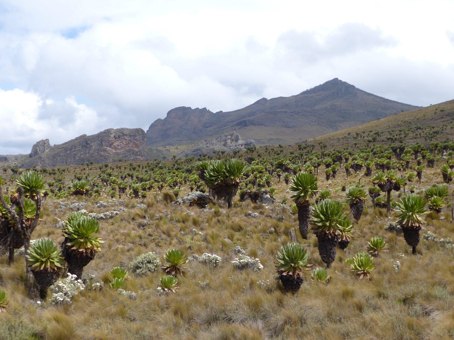
Mount Elgon hiking ranges from short forest walks to several day treks reaching Wagagai at 4,321 metres, with Sasa, Sipi, Piswa and other routes giving different gradients and trailheads. Most Uganda side treks are organised through Mbale, Budadiri, Sipi or Kapkwai. The mountain is an extinct volcano whose upper trails cross forest, bamboo, heather and high moorland before reaching the caldera area.
Hiking snapshot. Choose the route before booking transport or accommodation. Mount Elgon covers a wide area, and Budadiri, Kapkwai and northern trailheads are not interchangeable meeting points.
Mount Elgon Hiking Routes for the Wagagai Trek
The main Mount Elgon hiking routes differ more in gradient, starting elevation and access than in the final goal. Sasa is the direct western option from Budadiri. The Sipi route starts higher near the Forest Exploration Centre at Kapkwai. Piswa reaches the upper mountain from the north. Suam and Bushiyi add other possibilities depending on current operations and the plan agreed with park staff or a trekking provider.
A route should be chosen around your walking style. A short itinerary can mean bigger daily effort. A longer one can give more time to settle into altitude and spend time on the upper mountain. Do not select Sasa only because it reaches the summit in fewer days if steep first days are a poor fit for your knees or fitness.
Route names also appear inconsistently across older websites. Confirm the actual trailhead, first camp and exit point on the itinerary you are paying for. Some trips go up one route and descend another, which changes transport logistics at both ends.
Sasa Route Mount Elgon Hiking Trek
The Sasa Route trek starts from Budadiri in the Sironko Valley and is the shortest established line to the upper mountain in official Uganda Wildlife Authority material. Its main trade off is the quick gain in altitude. The first day rises strongly from the lower slopes, so the route can feel harder than its total trip length suggests.
Older descriptions refer to the Mudangi Cliffs on the early ascent. Traveller reports note that infrastructure on the steep section has changed over time, which is a good reminder not to plan from an old trip report alone. Ask what the current trail condition is when you book.
Sasa suits hikers who are fit, comfortable with steep ground and willing to gain height quickly. It is less attractive for somebody who wants the gentlest start possible. A dedicated Sasa Route page can go deeper into camps and day sequence, while the main decision here is simple: direct does not mean easy.
Route choice. If your main worry is a steep first day, ask about a route that starts higher or gains elevation more gradually. If time is tight and your fitness is good, Sasa may make more sense.
Sipi Route Mount Elgon Hiking Trek
The Sipi Route hike begins from the Forest Exploration Centre at Kapkwai at a higher elevation than Budadiri. Uganda Wildlife Authority describes it as a longer but gentler ascent. That can make the opening stages easier to pace, though the trip still reaches high mountain conditions.
Starting higher does not remove altitude from the trek. It simply changes how the first part feels. Hikers still need warm sleep clothing, waterproof protection and a pace that does not turn every day into a race. A guide may also combine the route with features on the upper mountain rather than treating the summit marker as the only goal.
This route is practical for travellers already staying around Sipi or Kapchorwa. If you are sleeping in Mbale, allow enough morning time to reach Kapkwai before the walking day begins. The final road to a trailhead is part of the trekking plan, not an afterthought.
Piswa and Northern Mount Elgon Trekking Routes
Piswa Route trekking reaches Mount Elgon from the northern side and is another established option named in official park material. It tends to appeal to hikers who have more time and want a different line through the mountain rather than the shortest summit schedule.
Northern access changes the road plan before and after the hike. If a trip enters on one side and exits on another, the vehicle must meet you at a different point. Confirm that transfer arrangement before going onto the mountain because mobile communication can be unreliable in remote sections.
Suam is also named among northern options in official information. Trail availability and the exact itinerary should be checked with Uganda Wildlife Authority or the trekking provider before travel. A route mentioned in an old guide is not proof that every camp, road or service is operating in the same way now.
Bushiyi Mount Elgon Hiking Route
The Bushiyi Trail has become another Mount Elgon trekking option on the Uganda side. Recent traveller reports describe a start that can feel gradual before the route becomes harder toward higher camps. That pattern can suit hikers who prefer a less abrupt opening day.
One useful detail from recent trip reports is luggage planning. Porters may be allocated to shared expedition equipment, food and camping gear rather than automatically carrying every personal item. Ask what your porter allocation covers. A light personal day pack makes a large difference over repeated climbing days.
Water treatment is another detail worth discussing before departure. Bottled water is not a realistic solution for every day on a mountain trek. Ask how the team treats or boils water and carry a personal backup method if that fits your travel style.
Wagagai Summit Hiking and Mount Elgon Caldera
Wagagai hiking reaches 4,321 metres, the highest point on Mount Elgon. The summit itself is normally reached on foot without the technical ice work associated with higher alpine climbs, but altitude still changes how the day feels. Breathing is slower, legs tire sooner and cold can be sharp when cloud and wind move in.
The upper mountain is arranged around a broad caldera rim rather than a single cone. Jackson’s Pool sits at about 4,050 metres beside the western trail system, with Jackson’s Peak rising nearby. Hikers may cross moorland and volcanic ground for long periods above the forest zone.
Do not judge the trek only by a photograph at Wagagai. Cloud may hide distant views, and wet weather can make summit day more about steady movement than scenery. The vegetation change, caldera area and time on the high moorland are part of the reason to walk Mount Elgon.
Mount Elgon Trekking Features: Caves, Hot Springs and Moorland
A Mount Elgon trek is more than a line to Wagagai. Depending on the route, hikers pass caves, pools, volcanic rock, high moorland and areas associated with hot springs in the caldera. Lower trails move through forest and bamboo before the vegetation opens higher up.
The change underfoot matters. Forest paths can be muddy and root covered, while higher ground can feel exposed to wind and cloud. A route that looks gentle on an elevation profile can still become slow after heavy rain.
Ask which natural features are actually included on your itinerary. Route names cover large areas, and seeing a cave or hot spring mentioned in a general Mount Elgon article does not mean every trek passes it.
Mount Elgon Day Hiking and Lower Forest Walks
A Mount Elgon day hike is a good alternative for travellers who do not want several nights of camping. The Forest Exploration Centre at Kapkwai is associated with lower forest walks of different lengths, with routes passing forest, waterfalls, caves and viewpoints.
These walks still need proper footwear. Rain, roots and clay can make a short trail slower than expected. Birders may also prefer a lower forest hike because moving slowly gives more time to watch the canopy rather than covering summit distance.
A day hike does not test how your body will respond above 4,000 metres, so do not use it as proof that a summit trek will be easy. It is better treated as its own Mount Elgon activity or as a gentle day before another part of the trip.
Mount Elgon Hiking Difficulty and Altitude
Mount Elgon hiking difficulty comes from daily walking, altitude, mud, cold and repeated camping more than from technical climbing. A person who walks long distances comfortably on flat ground may still find steep climbing and descending hard on knees and calves.
Altitude deserves respect at 4,321 metres. Move at a pace that lets you speak without gasping, drink regularly and tell the guide if you develop a worsening headache, unusual nausea, confusion or severe weakness. Do not hide symptoms because you want to reach the summit marker.
Recent mountain reviews mention cold nights as one of the biggest surprises. Thick socks and gloves can matter as much as fitness once you stop walking. A sleeping mat also matters because cold transfers through the ground and hard bunk surfaces can make rest poor.
Mountain reality. Strong legs do not make a hiker immune to altitude. The best schedule gives your body time, keeps the pace steady and leaves room to turn back if symptoms become serious.
Mount Elgon Hiking Camps and Trek Support
A multi day Mount Elgon trekking trip needs more support than a day hike. Depending on the route and operator, the team can include a guide, ranger escort, porters and a cook. Camping equipment, food and water treatment also need to be assigned clearly.
Ask exactly what is supplied. Do not assume a tent, mattress, sleeping bag, head torch or waterproof bag is included because the itinerary says “camping.” Hiker reports show that basic shelters or bunk structures exist at some camps, but carrying a tent may still be part of the plan.
Porter expectations should be settled before the trail. Know the weight allowance, whether personal luggage is included and what you are expected to carry yourself. Packing a smaller day bag with water, rain gear, warm layer, snacks and personal medication keeps the important items with you even when the main gear moves with porters.
Mount Elgon Hiking Weather and Trail Conditions
Mount Elgon hiking weather is never completely predictable. Official park guidance describes June through August and December through March as the drier climbing periods, but rain still occurs. The mountain receives enough rain to support dense lower vegetation and watercourses, so waterproof preparation is needed in every season.
Mud is more than an inconvenience. It slows descents, increases slipping and can soak footwear for the next day. Gaiters can help keep mud and water out of boots. Carrying dry sleep socks in a sealed bag is a simple trick repeated mountain hikers tend to value after the first wet day.
Upper camps can be cold at night. Keep one warm layer dry for camp rather than wearing every layer in rain during the day. A wet fleece is much less useful when temperatures fall after sunset.
Mount Elgon Hiking Packing and Personal Gear
A Mount Elgon hiking pack should solve four problems: wet weather, cold nights, uneven walking and several days away from shops. Good hiking footwear, rain jacket, warm layers, gloves, hat, head torch, water bottles, personal first aid items and dry bags form the core.
Do not overpack clothing. Repeating hiking clothes is easier than carrying a heavy bag. Protect the items that must stay dry: sleep clothes, phone, documents and medication. A separate pair of dry socks for camp can improve a cold evening more than an extra shirt.
Trekking poles can help on muddy descents if you already know how to use them. A small water filter or treatment backup can also be useful when the expedition plan relies on boiled or treated mountain water. Keep personal essentials in your day pack rather than sending everything ahead with a porter.
Getting to Mount Elgon Trailheads for a Hiking Trip
Mount Elgon trailhead access usually starts with choosing the route. Mbale is the main city base on the western side. Budadiri serves Sasa. Kapkwai serves the Sipi route side. Northern routes need different road transfers.
Roads from the main Mbale to Kapchorwa corridor branch toward smaller mountain access roads. Rain can slow those last sections. If your trekking day starts early, sleeping in Mbale, Sipi or closer to the trailhead depends on how much transfer time you want before the first climb.
Do not tell a driver only that you are going to Mount Elgon National Park. Give the exact ranger post or meeting point. The mountain is too large for a vague destination to work well.
Mount Elgon Hiking Guide FAQ
How much does Mount Elgon hiking cost? The final cost combines park access, trekking activity charges where applicable, guide and ranger arrangements, porter support, food, camping equipment and transport. Uganda Wildlife Authority’s Mount Elgon page displays USD 35 park entry for foreign non residents, USD 25 for foreign residents and UGX 20,000 for East African visitors. Confirm the latest trekking tariff and full trip inclusions before paying because park tariff periods and service prices can change.
How many days are needed to hike Mount Elgon? Official park material describes three days as a minimum for an extended summit hike, while four days is a more comfortable Sasa schedule. Other routes and route combinations can take longer. A day visitor can still do lower forest walks without attempting Wagagai.
Which Mount Elgon route is easiest? No route is easy for everybody. Sasa is direct but gains height quickly. The Sipi route starts higher and is described as gentler in its ascent. Your fitness, knees, available days and preferred trailhead should decide the choice.
Do I need a guide to hike Mount Elgon? Multi day trekking should be arranged through the park system with the required guide and ranger support for the chosen route. Do not treat the upper mountain as an unassisted backpacking trail. Confirm the current UWA requirements before arrival.
Can a beginner hike Mount Elgon? A fit beginner can consider the mountain with good preparation and a route suited to their ability. Start with long walks and hills before travel, carry less personal weight and allow enough days. A lower forest hike is a better choice if you are unsure about several days of camping.
What is the coldest part of a Mount Elgon trek? Nights and early mornings at higher camps are usually the part hikers notice most. Wind, wet clothing and sleeping on cold ground can make the temperature feel harsher. Keep sleep clothing, socks and an insulating layer dry.
What happens if I feel altitude sickness on Mount Elgon? Tell the guide at once. Mild symptoms can worsen, and serious symptoms require descent. Do not continue upward to protect a schedule or summit goal. The mountain will still be there another time.
Mount Elgon Hotel & Spa in Mbale can provide a room, meals and spa time before or after a mountain trek. Contact the hotel with your dates for the Mbale stay, then confirm your route, park requirements, guides, porters and camping arrangements with Uganda Wildlife Authority or the trekking provider responsible for the climb.